discover hkbu
Bringing history of the Battle of Hong Kong to life
29 Oct 2021
Older Hong Kong residents often talk about the terrible "three years and eight months" during WWII and the hardships that people suffered during the Japanese occupation. Leading up to the fall of Hong Kong was an 18-day conflict known as the Battle of Hong Kong (8-25 December 1941), and a new interactive map developed by researchers from the Department of History is shedding light on the clash.
A short but significant battle
The battle remains the most significant military event to have ever taken place on Hong Kong soil in modern times, as more than 2,000 soldiers and around 4,000 civilians were either killed or wounded. Eight decades have gone by, and today, many Hong Kong people find it hard to visualise and comprehend what occurred during the war. To the digital natives, the traditional methods used to teach history often appear less engaging. So how do we incentivise and encourage them to learn about this important period of history that occurred so close to home? Dr Kwong Chi-man, Associate Professor of the Department of History, has a solution.
An ongoing project to promote historical education
Dr Kwong and his team have been researching the Battle of Hong Kong since 2011, and they have published books and papers in both Chinese and English, including Eastern Fortress: A Military History of Hong Kong, 1840–1970, which won the Hong Kong Book Prize in 2019.
Later, Dr Kwong received a grant from the Quality Education Fund (QEF) to develop an electronic interactive historical map about the battle that can be used in Hong Kong schools. The researchers behind the map hope to stimulate students’ interest in learning about history and maps, while promoting the study of history in society.
The team spent two years researching, analysing primary sources and collecting first-hand historical materials, with the support of HKBU's Knowledge Transfer Office and the University Library's Digital and Multimedia Services Section. The Chinese and English versions of the map were first launched online in August 2021, and the team is now working on designing teaching resources for teachers which will show them how to use the map with students in the classroom. A mobile version, which is optimised to fit on the screens of smart devices, is also readily available.
Presenting history in a novel way
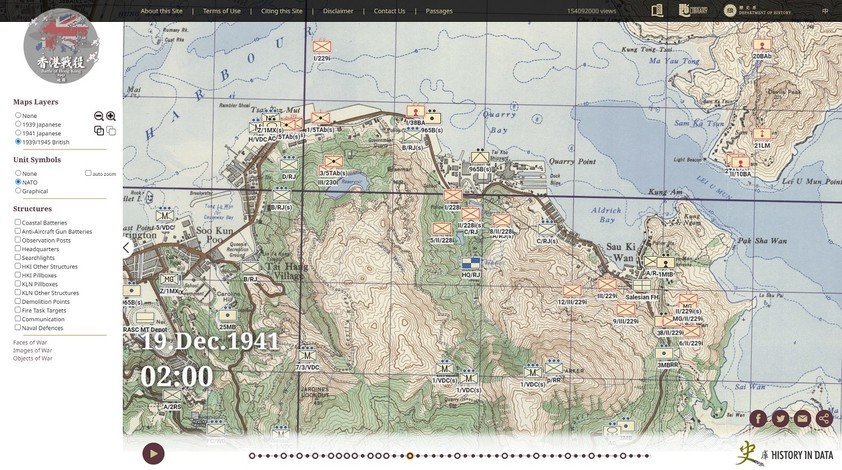
One innovative and notable feature of the map is the use of the Historical Geographic Information System (HGIS) to overlay the wartime maps of the British and Japanese forces on a Google Map. As such, users can see the overall picture of the battle, marked with the distribution of the fighting forces at different points in time, locations of relevant military sites around Hong Kong, and first-person stories.
By combining digital technologies and historical content, viewers can freely interact with the different categories of information, and they can explore the battle's timeline and experience historical events in a way that goes beyond the traditional textual dimension.
Displayable items include military units, more than 300 wartime military structures, about 80 personal witness accounts from combatants to civilians, descriptions of weapons, scenes of war crimes, wartime photos, and recent photos taken at historical sites by Dr Kwong's research team.
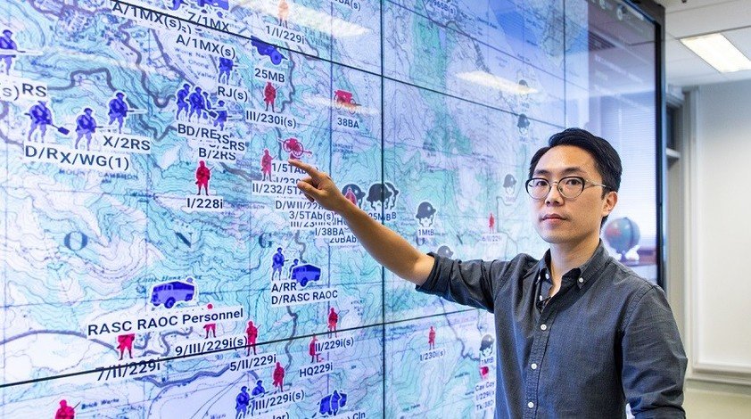
Members of Dr Kwong's team include Professor Clara Ho, Professor Timothy Wong, Dr David Schley and Dr Tam Ka-chai from HKBU's Department of History, and they were joined on the project by military history scholars Mr Tony Banham, Mr Tsoi Yiu-lun and Mr Ko Tim-keung. Together, they are introducing Hong Kong students and the public to a pioneering way of teaching and learning about history. Users will also be able to engage with the historical materials from a spatial perspective and in temporal dimensions through the visualisation of data and information. The self-directed and interactive nature of this map will make historical education an enjoyable and awe-inspiring experience.
Access the map here:
https://digital.lib.hkbu.edu.hk/1941hkbattle/en/index.php